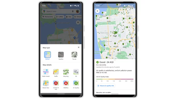
Before venturing outside right now in the northeastern U.S., it's a good idea to not only check wildfire smoke maps, but to check the air quality where you live.
There's a reliable option called airnow.gov which monitors in real time across the U.S. working with federal agencies including NASA, NOAA, and the EPA. But there's also existing tool from Google Maps you may want to consider.
Google introduced a tool in June 2022 for checking air quality conditions on both Android and iOS devices, to help "make more informed decisions about whether it’s safe to go on a hike or other outdoor adventures," the company says. But it's especially useful now for, say, air quality emergencies like the eastern U.S. is experiencing.
SEE ALSO: How to protect yourself from Canada wildfire smokeThe air quality layer tool indicates Air Quality Index (AQI), which is typically used by governmental agencies to inform the public about how polluted it is in a given location. Currently only available in the U.S., Google Maps will display data from the Environmental Protection Agency, along with PurpleAir, a sensor network that provides hyper-local air quality data.
Featured Video For You Canada wildfires turn New York into the world's most polluted cityData from PurpleAir can also be found on Google Nest displays.
How to check air quality on Google Maps
1. Open up Google Maps and either hit the arrow button in the bottom right of the screen to pinpoint your location, or type the location you're thinking of visiting in the search bar.
2. Press the layers button in the top right under the search bar to bring up the layers menu.
There's your air quality tool in the layers section. Credit: Screenshot: Google Maps3. From there, you can select "Air Quality" under Map details.
4. Google will then display the index, giving you up-to-date information about what it's like outside in your location.
And there's your air quality. Credit: Screenshot: Google MapsAlongside the air quality tool, Maps also introduced a feature to prepare for wildfire season, allowing users to identify active fires in their areas.


