Hurricane Lee was showing signs Thursday morning that it would rapidly intensify again, days before a precarious and uncertain northward track that much of the US East Coast will have to watch closely.
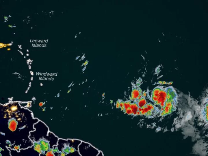
The Category 1 storm was packing maximum sustained winds of 80 mph as of early Thursday, located about 965 miles east of the northern Leeward Islands, according to the National Hurricane Center.
Lee could near Category 5-strength as it approaches the eastern Caribbean this weekend and is still expected to be a dangerous hurricane over the southwestern Atlantic early next week. Lee's maximum forecast intensity of 155 mph would make it the strongest storm in the Atlantic basin this season. That forecast is also just 2 mph shy of Category 5.
"All the ingredients are in place for the storm to really intensify," Jason Dunion, director of NOAA's Hurricane Field Program, told CNN. "This storm definitely has the potential to be a Category 5," Dunion said.
It's too soon to know whether this system will directly impact the US mainland, but even if the hurricane stays off the coast, dangerous surf and rip currents will threaten the Eastern Seaboard.
There is increasing confidence that the center of Lee will pass to the north of the northern Leeward Islands, the Virgin Islands and Puerto Rico this weekend and into early next week. There is a potential for tropical storm conditions to occur on some of these islands over the weekend.
Swells generated by Lee are expected to reach portions of the Lesser Antilles on Friday, and the British and US Virgin Islands, Puerto Rico, Hispaniola, the Bahamas, and Bermuda this weekend. These swells are likely to cause life-threatening surf and rip current conditions.
The storm had rapidly strengthened on Wednesday: Its sustained winds strengthened by 35 mph in the 24 hours after it formed as a tropical depression Tuesday morning. Even more rapid intensification is expected starting Thursday. Lee is expected to reach Category 3 strength by Friday morning and potentially Category 4 strength by Friday evening.
The forecast track takes the hurricane across some of the warmest waters in the Atlantic Ocean and through relatively calm upper-level winds, which will allow Lee to explode in strength.
The waters in the Atlantic are not quite as warm as the steamy conditions in the Gulf of Mexico, which gave rise to Hurricane Idalia last week. However, sea-surface temperatures across the portion of the Atlantic Ocean that Lee is set to track through are still a staggering 2 degrees Celsius (3.6 degrees Fahrenheit) above normal after rising to "far above record levels" this summer, according to David Zierden, Florida's state climatologist.
"To get to Category 4 or 5 intensity the environment has to be nearly perfect, which it looks like is the forecast for Lee," Zierden told CNN.
The last Category 5 hurricane to roam the Atlantic basin was 2022's Hurricane Ian. Before that, 2019's Dorian and Lorenzo were the most recent hurricanes to achieve the feat. Only 39 Category 5 hurricanes have occurred since 1924, according to data from NOAA.