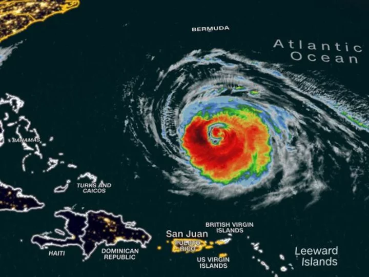
Hurricane Lee increased in size late Monday in the Atlantic and still is expected to grow significantly this week, forecasters say -- growth that will help determine the extent of its impact on the US Northeast, Bermuda and Canada.
Lee, a Category 3 hurricane on Tuesday morning, was centered about 575 miles south of Bermuda with maximum sustained winds of 115 mph, the National Hurricane Center said.
Though it could strengthen slightly Tuesday, it is then expected to weaken, grow in size and speed up after it makes its northward turn in the coming days.
Even if it's weaker, a larger storm could impact a more widespread area. A larger Hurricane Lee, then, is more likely to affect the Eastern Seaboard -- even if not through a direct landfall.
Tuesday morning, Lee's hurricane-force winds extended 80 miles from its center -- up 5 miles from evening. Tropical storm-force winds extended 185 miles from its core.
Those tropical storm-force winds could extend over 300 miles from Lee's center later this week, National Hurricane Center Director Michael Brennan said in a Monday storm briefing.
"It is still expected to significantly increase in size, and hazards will extend well away from the storm center by the end of the forecast period," the hurricane center said Monday night.
Lee's core is expected to turn north by midweek and pass near, but west, of Bermuda late Thursday and Friday, and could deliver strong winds, rain and high surf to the island territory, forecasters said.
It's too soon to know the extent of the impacts Lee might have along the Northeast US and Atlantic Canada late this week and this weekend, the hurricane center said.
"However, because wind and rainfall hazards will likely extend well away from the center as Lee grows in size," people in those areas should monitor the forecast for the next several days, the hurricane center said.
Regardless of its final track, the storm will send big waves to a growing area of the East Coast throughout the week as it tracks northward. This will cause coastal erosion, dangerous surf and life-threatening rip currents at beaches.
Dangerous surf was already happening along the Florida coast and on many of the far eastern Caribbean islands as well as the British and US Virgin Islands, Puerto Rico, Hispanola, the Turks and Caicos, the Bahamas and Bermuda.
Rip currents have already killed 71 people in the US this year, preliminary National Weather Service data shows. Three people in New Jersey died in rip currents kicked up in the wake of Hurricane Franklin last week.
Lee, which was a Category 1 storm Thursday, intensified with exceptional speed into rare Category 5 status as it moved west across the Atlantic, more than doubling its wind speeds to 165 mph in just a day.


