Hurricane Otis, a Category 5 storm, is expected to make landfall Wednesday morning near Acapulco in Mexico, threatening to lash the coastal region with destructive winds and potentially "catastrophic storm surge," forecasters say.
As of Tuesday night, Otis was packing winds of 160 mph with higher gusts while its core was about 55 miles south-southeast of Acapulco, moving north-northwest at 9 mph. Landfall is expected by early Wednesday near or just west of the city, a beach resort town on Mexico's Pacific coast, the hurricane center said.
A hurricane warning is in effect for coastal Punta Maldonado westward to Zihuatanejo. A hurricane watch and tropical storm warning are also active from Lagunas de Chacahua to Punta Maldonado.
Otis' primary threats are damaging winds, heavy rainfall and dangerous storm surge.
Strong winds of up to 73 mph were expected to reach the Mexico's Pacific coast Tuesday evening and then spread to other areas throughout Wednesday.
Otis is also forecast to create life-threatening surf and rip current conditions. Hurricane-force winds extend outward up to 30 miles from the center while tropical-storm-force winds extend outward up to 70 miles, the hurricane center explained.
Those winds are forecast to combine with a "potentially catastrophic storm surge" that could cause life-threatening coastal flooding near where it's forecast to make landfall Wednesday morning.
"Near the coast, the surge will be accompanied by large and destructive waves," the hurricane center said.
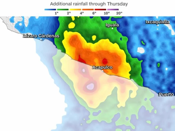
Additionally, between 8 to 16 inches of rain totals are expected through the end of the week, with some areas seeing up to 20 inches of rain. The heavy rainfall could lead to flash and urban flooding as well as mudslides in higher terrain areas, the hurricane center warned.
If Otis makes landfall as a Category 5 hurricane, it would be the first Category 5 landfall for the East Pacific, according to the NOAA Hurricane Database. The previous strongest landfall was Hurricane Patricia in 2015, which made landfall as a Category 4 Hurricane with winds of 150 mph.