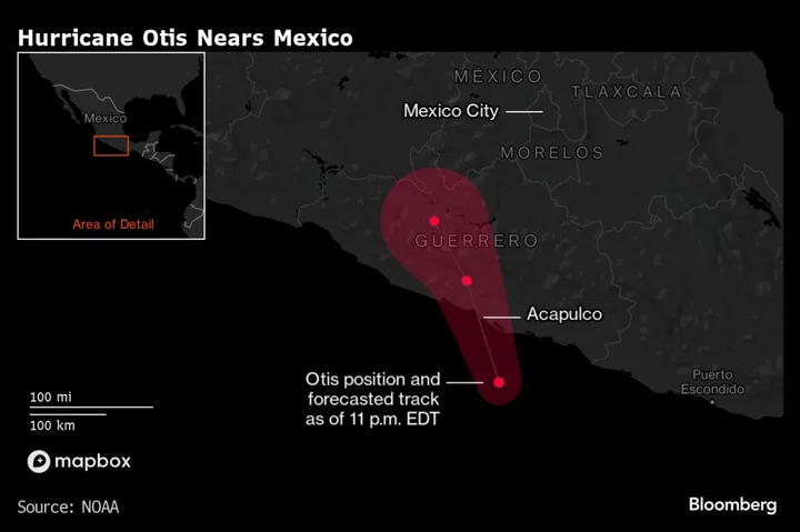
Hurricane Otis exploded in strength as it neared the tourist hotspot of Acapulco on Mexico’s Pacific Coast, becoming a deadly Category 5 hurricane with winds capable of collapsing homes, ripping apart power lines and tossing trees.
The storm rapidly intensified with maximum sustained winds of 165 miles (270 kilometers) per hour with the eyewall moving ashore near Acapulco, the US National Hurricane Center said in a 12 a.m. New York time advisory. It said Otis would remain a Category 5 hurricane through landfall “within the next few hours.”
“There are no signs of this explosive intensification stopping,” wrote Eric Blake, a senior hurricane specialist at the center.
Mexican President Andres Manuel Lopez Obrador asked the residents of Guerrero state, where Acupulco is located, to move to shelters and said that a Navy security plan is already in place. “Remain in safe places, away from rivers, streams, ravines and be alert,” he said on X, the platform formerly known as Twitter.
Even if the storm misses Acapulco just to the west, that would still mean the city of about 1 million people would be hit by some of its strongest winds.
Otis could push a “potentially catastrophic” storm surge ashore as it makes landfall, the hurricane center said. In addition to the winds and the coastal flooding, Otis could drop 8 to 16 inches of rain, with some areas getting up to 20 inches, across the Mexican states of Guerrero and Oaxaca.
“This rainfall will produce flash and urban flooding, along with mudslides in areas of higher terrain,” the center said.
READ MORE: How Global Warming Is Causing More Weather Extremes: QuickTake
A Category 5 storm can destroy framed homes, rip roofs off buildings and collapse walls. “Power outages will last for weeks to possibly months,” according to the center’s website. “Most of the area will be uninhabitable for weeks or months.”
The hurricane’s top winds have increased by 80 mph in the last 12 hours, which is the fastest rate ever recorded in the eastern Pacific since the satellite era began in 1966, Colorado State University hurricane researcher Phil Klotzbach said in a social media post.
--With assistance from Kevin Varley.
(Updates with latest hurricane report in second paragraph.)
Author: Brian K. Sullivan and Alex Vasquez


