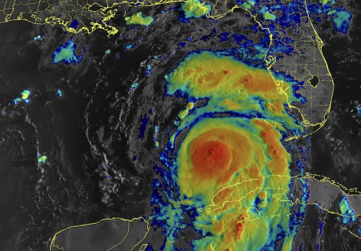
Hurricane Idalia is picking up steam: It's expected to bring 100-plus mph winds, destructive storm surge, and heavy rains to Florida.
Many of the worst impacts will happen in parts of the state's Gulf Coast, where Idalia will make landfall Wednesday morning. For those interested in following or understanding the effects of such a powerful storm, there are a number of live webcams showing the event, which you watch below.
Idalia, a tropical storm on Monday, has now intensified into a hurricane. The National Hurricane Center expects it to strengthen into "major hurricane" (Category 3) before landfall — with wind speeds of at least 111 mph — as conditions become more favorable for a hurricane, notably the decrease in wind shear (which are winds that can impede the formation of a strong, coherent storm). What's more, Idalia will travel over extremely warm ocean water, which provides energy for these storms. The water in Idalia's path is the warmest it's been in at least decades.
This all sets the stage for the storm to strengthen.
"We expect it to rapidly intensify," Joel Cline, the National Weather Service Tropical Program manager, told Mashable on Monday evening. "This will be a rapid intensifier from a tropical storm."
"We expect it to rapidly intensify."Although an intense storm is unfortunate news for many people in the Florida region, the good news is this intensification expectation has been forecast days in advance, allowing people to follow the informed guidance from local officials, Cline noted.
The impacts will be serious.
"There is a danger of life-threatening storm surge inundation from Idalia along portions of the Florida Gulf Coast where a Storm Surge Warning is in effect, including Tampa Bay & the Big Bend," the National Hurricane Center wrote. "Residents in these areas should follow advice from local officials." (Storm surge is caused by potent winds pushing water into the shore, at times causing violent inundations.
Heavy rains from Idalia pose great risk, too. In recent years, freshwater flooding from heavy deluges has driven the majority of tropical storm-caused deaths. After landfall, Idalia will weaken but still carry potent rain bands over Florida, in a wide area between Tallahassee and Jacksonville. The ocean will certainly cause coastal flooding, but expect lots of flooding from rainfall in both coastal and inland areas.
"The rain will come down heavily at times," Tony Fracasso, a National Weather Service meteorologist, told Mashable.
Tampa Bay Riverfront webcam
Tampa Bay is expected to see some four to seven feet of storm surge, along with hurricane force winds.
Frenchy's Clearwater Beach Cam
Live footage of Clearwater Beach from Frenchy’s Rockaway Grill. Clearwater beach is located just west of Tampa.
Homosassa Springs live webcam
This webcam is situated just inland of the coastal Homosassa region, at Ellie Schiller Homosassa Springs Wildlife State Park. Some of Florida's iconic manatees live in these springs.
Gulf Coast live webcams
The following live webcams aren't on YouTube, so they couldn't be embedded in this post like the livesteams above, but they are situated close to where Hurricane Idalia will make landfall. You'll have to click on the links:
- Homosassa Live View: A webcam at MacRae's of Homosassa, just inland of Crystal River National Wildlife Refuge.
- Cedar Key Beach Webcam: Live webcams at Cedar Key, Florida, near where Hurricane Idalia will make landfall.
- St. George Island Webcam: St. George Island, located in the NHC's "Hurricane Warning" zone, is located off the Florida Panhandle.
How is Hurricane Idalia related to climate change?
Climate change is impacting hurricanes. Some of these impacts are clear, particularly more serious rainfall and historic flooding, along with higher storm surges. Other impacts, like how the relentless warming oceans are affecting how strong these storms grow, are an intensive and ongoing area of research.


