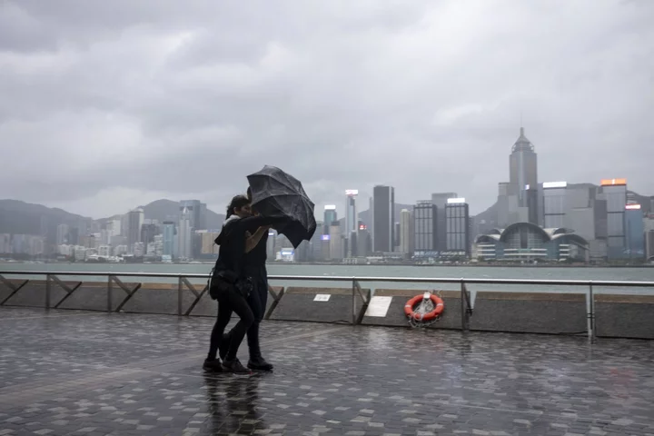
Hong Kong warned of heavy rain over the weekend as the latest forecast showed Typhoon Koinu moving closer toward the finance hub than earlier predicted.
The city’s observatory said it will consider issuing its second-lowest storm No. 3 signal between 5 p.m. and 8 p.m. on Friday. Whether the No. 8 alert — which effectively shuts down the city including the stock market — is raised will depend on Koinu’s intensity and distance from Hong Kong, it said.
The typhoon is projected to be closest to the city late Sunday and early Monday, according to the observatory. A northeast monsoon will help weaken Koinu into a tropical storm packing winds of 75 kph by then, it said, adding that rainfall will be heavy at times. Koinu earlier brushed past the southern tip of Taiwan, hitting it with 343 kph gust of wind.
Typhoon Koinu Hits Taiwan With One of Strongest Wind Gusts Ever
The approaching storm caps a period of extreme weather for the city, which lies at the northern fringe of the subtropical zone. The city just endured its hottest ever October day and Mid-Autumn festival. September was the wettest on record for that month, as well as having the longest string of consecutive “very hot” days — with the temperature exceeding 33C for 10 days.
Hong Kong insurance claims caused by natural disasters may climb to a record and exceed $500 million this year should Koinu bring heavy rain to the city and cause flood losses, Bloomberg Intelligence analyst Steven Lam said in a note on Wednesday.
The storm has already caused one fatality in central Taiwan where an elderly woman bled to death after being injured by glass shattered by strong wind in her home, according to the Central Disaster Prevention and Response Council. The typhoon has also led to more than 300 injuries around Taiwan and caused NT$6.5 million ($201,250) damage to agricultural crops, the council said.
The unique topography of Hong Kong — roads and buildings cut into steep hillsides — makes the city vulnerable to flooding and landslides from torrential summer rains that have steadily intensified over time due to climate change. Record-breaking rain caused by the remnants of Typhoon Haikui last month flooded streets, submerged vehicles and triggered landslides.
The city was also hit by its strongest typhoon in five years at the start of September. With a maximum sustained wind of 230 kph near its center, Saola was the second-most intense tropical cyclone affecting the South China Sea since 1950, according to Hong Kong’s observatory.
If the observatory hoists the No. 8 signal, it would be the second straight year the warning has been raised three times, compared with an annual average of twice in the decade through 2022, according to Lam.
Hong Kong’s government is pushing for quicker action on a proposal to keep financial markets open during typhoons, instructing a task force to submit a workable plan within weeks, Bloomberg News reported on Thursday.
Hong Kong Accelerates Push to Keep Markets Open During Typhoons
The city is one of the only major financial centers to regularly halt trading due to extreme weather. The issue has come to fore as initial public offerings and volumes slump, sapping revenue for Hong Kong’s coffers and undermining the city’s appeal as a financial center.
Koinu was estimated to be about 380 km east of Hong Kong at 8 a.m. and is forecast to move west at about 10 kph per hour toward the coastal waters of eastern Guangdong, according to the observatory.
--With assistance from Dominic Lau and Betty Hou.
(Updates with casualty and damages in Taiwan in the sixth paragraph.)

